Flash Flood Fury In Uttarakhand, A Classic Example Of Climate Change
So far in October, Uttarakhand has recorded a whopping 192.6 mm of rainfall against 31.2 mm

Extreme weather events are not new to the country. However, the increasing frequency of these events are. All thanks to climate change, which has been altering weather patterns across India.
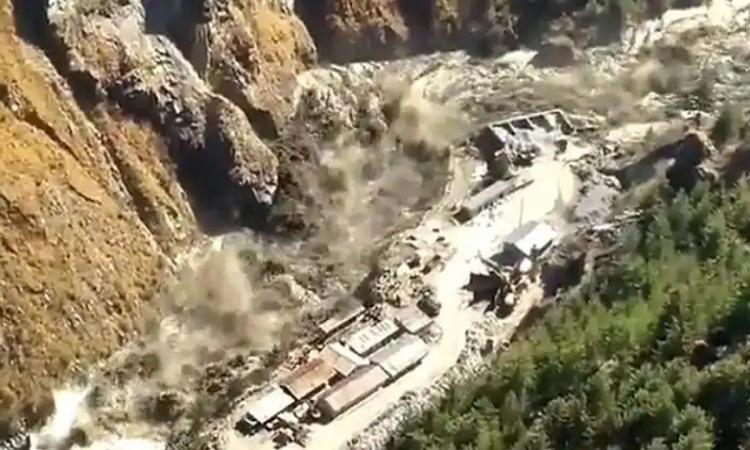
Latest example is the torrential rains in Uttarakhand earlier this week. The weather remains calm over Uttarakhand post the retreat of the Monsoon season. The state seldom witnesses any major spell of rain and thundershowers. However, this has not been the case this season. The state saw incessant rainfall beginning Sunday night and went on till Tuesday.

So far in October, Uttarakhand has recorded a whopping 192.6 mm of rainfall against 31.2 mm. Out of this, 122.4 mm of mm was recorded in 24 hours itself. Reportedly, around 52 people lost their lives on account of heavy rainfall and series of landslides. The worst affected district was Nainital that saw the highest death toll of 28 deaths.
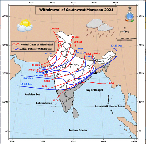
The onus of these untimely showers over the state can be attributed to the extended stay of the Southwest Monsoon 2021 over the country. The presence of Monsoon current over the region means the presence of abundance of moisture over the landmass, keeping weather conditions favourable for the formation of the weather systems.

Late withdrawal of Southwest Monsoon is new normal, courtesy Climate Change
The latest report by the United Nations led Intergovernmental Panel on Climate Change (IPCC)- Working Group I the ‘Sixth Assessment Report Climate Change 2021:The Physical Science Basis’ has already indicated that increasing global temperatures are changing Monsoon patterns across Southeast Asia. A warmer climate will intensify very wet and very dry weather and climate events and seasons, with implications for flooding or drought (high confidence), but the location and frequency of these events depend on projected changes in regional atmospheric circulation, including monsoons and mid-latitude storm tracks.
Monsoon has been breaching its normal withdrawal date for many years now. With this, the state-run India Meteorological Department (IMD) had also revised the commencement date of the Monsoon withdrawal from September 1 to September 17. Normally, the withdrawal process competes by October 15, which has not been the case for the last decade.

The low pressure area travelled all along the Northern Limit of Monsoon (NLM) which was then passing through parts of Central India. The system later moved north towards Uttarakhand and then recurved towards Uttar Pradesh. Also, post the retreat of Monsoon, dry northwesterly winds start blowing over North India. But the presence of multiple weather systems led to change in wind pattern and we could see strong humid easterly winds all along the Indo-Gangetic plains with depth of more than 8000 ft.
According to G P Sharma, President- Meteorology and Climate Change, Skymet Weather said, “It is very much evident that had the Monsoon departed timely, we would not have seen such torrential rains. Weather conditions were very favourable for such heavy precipitation on account of multiple weather systems coming together. While there was a western disturbance up in the hills, two low pressure areas were seen over Madhya Pradesh and the Bay of Bengal, respectively. However, what prompted these systems was the delayed withdrawal of Monsoon. Usually, weather systems do not travel inland, especially over the places from where Monsoon has retreated. And since by this time the NLM was still passing through Madhya Pradesh, these low pressure areas tended to travel deep inside the land.”
He further added, “Not only this, the low pressure area over Madhya Pradesh interacted with the western disturbance over the northern Himalayas and pulled it down. This not only enhanced the rainfall manifolds over Uttarakhand, but resulted in early snowfall over parts of Jammu and Kashmir. Since there is rare development of any weather system over the plains during this time of the year, we do not see much impact of any western disturbances over the northern states other than some light showers. Usually, we start witnessing changes in the track of western disturbances by the end of October but both the intensity and frequency of Western Disturbances increase by November only.”
Both the low-pressure areas travelling in the Bay of Bengal were the remnants of tropical storms Lionrock and Kompasu in the Pacific Ocean, which re-emerged in Indian seas and gathered strength. While the former travelled to Madhya Pradesh, the latter one affected West Bengal, Bihar and entire Northeast India.
“We are now in the firing range of Climate change, which has clearly altered the frequency, timing and track of weather systems during, before and after the Monsoon. We are in the second half of October and weather systems are still penetrating deep inside till Maharashtra,” said G P Sharma.
However, the mass destruction caused by inclement weather conditions is not only because of the climate crisis. It is quite evident that development plans and human interference are not complimenting the ecological balance of Uttarakhand.
Professor Y P Sundriyal, Head of Department, Geology, HNB Garhwal University said, “Higher Himalayas, both climatically and tectonically, are highly sensitive, so much so, that at first stance construction of mega hydro-projects should be avoided. Or else they should be of small capacity. Secondly, construction of roads should be done with all scientific techniques. At present, we just see roads are being made or widened without taking proper measures such as no slope stability, lack of good quality retaining wall and rock bolting. All these measures can restrict the damage done by landslides up to some extent.”
“There is a huge gap between planning and implementation. For instance, rainfall patterns are changing, temperatures have been increasing along with extreme weather events. Policy makers should be well versed with the geology of the region. There is no denying the fact of development but hydropower plants, especially in higher Himalayas should be of less capacity. Policy and project implementation should consist of local geologists who understand the terrain well and how it responds,” added Prof Sundriyal.
“There has been a manifold increase in the tourist influx over the years. Roughly counting, the state used to host around 6 lakh tourists per year which has now increased to over 15 lakhs. With this, there has been an increase in vehicular pollution, river pollution, construction activities, and commercialization. Construction of hydropower projects and road widening activities have had a major impact over the region. All these factors have contributed to the increase in temperatures along with change in rainfall pattern. We now see incessant rains that go on for 2-3 days at a stretch, while several days being left high and dry. Also, during the 1980s and 90s, snowfall was a prominent feature between December 20-25 in Joshimath region. But that changed over the years, with snowfall even giving a miss to the region,” said Atul Satti, a local environmental activist.
The writer of this article is Dr. Seema Javed, a known Environmentalist, Journalist and Communications Expert


