Fragile Ecosystem, Unplanned Development And Climate Change Causing Disasters In Joshimath
The entire responsibility of Joshimath caving in is on NTPC’s Tapovan Vishnugad Hydro Power Project, opine experts

Joshimath has been in news with scores of landslides and flash floods making appearances every now and then. In Chamoli district, Uttarakhand -The Raini village that once got global recognition for its Chipko Andolan & ecological consciousness now has to fight for its existence. The Rishigangariver had swollen due to torrential rains for three days straight, causing soil erosion from underneath the village in June and a large portion of Joshimath-Malari road beneath Raini village caved in. Massive flash floods that had ravaged Raini village on February 7,2021, following a glacier coming apart and an avalanche on the Alaknanda river. The huge mass of snow, water, boulders and silt slithered down Rishiganga, first damaging a 13 MW private hydel project and then flowing down to Dhauliganga river to swamp NTPC owned 520 MW Tapovan-Vishnugad hydropower project.

Speaking about the fragile system of Joshimath Anjal Prakash, Research Director and Adjunct Associate Professor, Bharti Institute ofPublic Policy, Indian School of Business and Lead Author for IPCC Reports says: “Joshimath is a very grave reminder that we are messing up with our environment to an extent that is irreversible. Climate change is becoming a reality. There are two aspects to Joshimath problem, first is rampant infrastructure development which is happening in a very fragile ecosystem like Himalayas and this is happening without much of a planning process in a way where we are able to protect the environment and at the same time bringing in basic infrastructure for the millions of people who are inhabitation in those areas. Secondly, climate change is a force multiplier. The way climate change is manifesting in some of the hilly states of India is unprecedented. For example, 2021 and 2022 have been years of disaster for Uttarakhand. There have been numerous climate risk events recorded like high rainfall events triggering landslides. We have to first understand that these areas are very fragile and small changes or disturbances in the ecosystem will lead to grave disasters, which is what we are witnessing in Joshimath. In fact, this is a particular point in history which should be remembered as what should be done and should be done in the Himalayan region. I am very much convinced that the Joshimath caving incident is caused by the hydro power project which has been operational in building the tunnel and was the major cause of concern for the residents. It has shown that water which has gushed out is from a fractured zone which has been punctured by the tunnel that has been leading to the devastating situation that we are in today. This is also in the pretext of several reports in the past. I would quote two reports of IPCC, published in 2019 and 2022, that have critically observed that this region is very prone to disasters. This means a very strong planning process must follow. In fact, the entire planning should be done at the bio-regional scale that should include what is allowed and what is not and has to be very stringent. I am not against bringing infrastructural development for people as these are the places of tourist interest. I understand the fact that people in these places here have no other means of survival considering the religious place they are in. However, it has to be done in a planned manner. We must leave out some things and look out for other ways for energy generation. The return investment cost in hydropower projects is very less when compared to the cost associated with environmental and ecological damage. Joshimath is a clear example of what one should not do in the Himalayas.”

Geological impact of retreating glaciers on the region :
The IPCC’s fifth Assessment Report cycle concluded that human influence on the climate system is “clear”. Since then, literature on attribution – the sub-field of climate science that looks at how (and by how much) human activities lead to climate change – has significantly expanded. Today, scientists are more certain than ever that climate change is caused by us. A recent study finds that humans have caused all of the warming observed since the preindustrial period, leaving no room for debate as to why the climate is changing. Since AR5, there has also been an increased focus on regional impacts, with scientists improving their models and understanding of what global climate change impacts will look like on a regional scale. The higher Himalayas were once home to a lot of glaciers, which have now retreated owing to global warming and climate change. Glacier is a moving mass of ice, soil and rocks and thus, it consists of lots of loose sediments. According to geologists, the retreating glaciers have left behind unlimited sediments which consist of an unstable mix of earth and rocks in the higher reaches of Himalayas. In such cases, even less rainfall is good enough to move the boulders and debris downstream. Hence, the higher Himalayan region is very unsuitable for dams and tunnels due to higher concentration of sediments. Raini village is located at an altitude of 3,700 meters above sea levels on the upper slopes of River Rishi Ganga. With such a high gradient, the chances of soil erosion and landslides increase manifold. The gravitational impact also increases at this altitude, bringing more damage and eroding river banks. Events witnessed near Raini village in the last few months are evidence to these facts. An expert committee appointed by the Supreme Court after the 2013 Uttarakhand disaster had strongly recommended against constructing a dam above an altitude of 2,000 meters, terming the region as a highly sensitive zone.
Ravi Chopra, Director, People’s Science Institute and Chairman of the Supreme Court appointed expert committee said, “Hydropower plants have had serious implications on the river ecosystem, geological environment, forest and terrestrial biodiversity and social infrastructure. In fact, the projects in the paraglacial zone above 2,000 m height obstruct river flow and are dangerous. There is no sustainable way to develop such projects given the flouting of environmental norms and challenges with the disposal of debris, accumulated muck. The recent avalanche plus the 2013 experience show that dams in the paraglacial zone are a danger to the people below.”
The cost of unplanned development:
The Himalayas are young and fragile in nature. Creating cracks and fractures in the rock which could widen in future and create a rockfall / slope failure zone. Experts believe that anthropological intervention has worsened it further. Be it development of hydropower plants, tunnels, or roads planned. The Tota Ghati example warns us that stable, hard rock dominated valley slopes, if not investigated critically for their geological fragility, lead to unprecedented slope instability having a cascading impact on the terrain. A slope failure is a phenomenon in which a slope collapses abruptly due to weakened self-retainability of the earth under the influence of rainfall or an earthquake. Blasting in mountains not only weakens the slopes along the road, but the impulse of the explosion and vibration generated by heavy excavators possibly would have transmitted upslope. Thus, geologists strongly recommend a critical evaluation of the geological and structural stability before subjecting mountains to large-scale mechanical excavation and blasting.
Professor Y P Sundriyal, Head of Department, Geology, HNB Garhwal University said, “Higher Himalayas, both climatically and tectonically, are highly sensitive, so much so, that at first stance construction of mega hydro-projects should be avoided. Or else they should be of small capacity. Secondly, construction of roads should be done with all scientific techniques. At present, we just see roads are being made or widened without taking proper measures such as no slope stability, lack of good quality retaining wall and rock bolting. All these measures can restrict the damage done by landslides up to some extent.” “There is a huge gap between planning and implementation. For instance, rainfall patterns are changing, temperatures have been increasing along with extreme weather events. Policy makers should be well versed with the geology of the region. There is no denying the fact of development but hydropower plants, especially in higher Himalayas should be of less capacity. Policy and project implementation should consist of local geologists who understand the terrain well and how it responds,” added Prof Sundriyal. NTPC-owned 520 MW Tapovan-Vishugad project was washed away in the February 7 massive flash floods and had suffered a loss of approx INR 1500 crores.
“According to a book ‘Central Himalaya’ by Heim, Arnold & August Gansser, Joshimath town of Chamoli district is situated on the debris of a landslide. Few houses had already reported cracks back in 1971, post which a report had suggested few measures that included
a) Conservation of the existing trees and plantation of more trees
b) boulders on which the town is located should be touched and c) Reinforced Cement Concrete (RCC) should not be done.
However, these measures were never followed. Several experts have cited that traditional housing construction technologies are able to withstand earthquakes and landslides much more strongly then the newly constructed infrastructures. Talking about the present situation, the ongoing crisis in Joshimath is primarily because of anthropogenic activities. The population has increased manifold and so has the tourist landfall.
Infrastructure has also amplified and has been unchecked. However, the town does not have a proper drainage system. Besides gradual weathering of fine material between the rocks of debris, water percolation has decreased the cohesive strength of the rocks over the time.
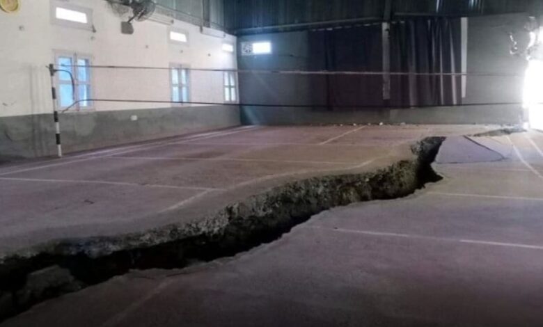
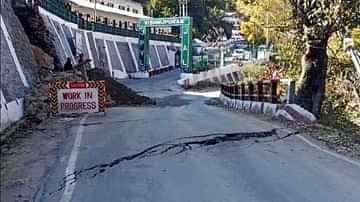
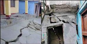
This has resulted in landslides, triggering cracks in the houses. Secondly, construction of these tunnels for Hydro power projects is being done through blasting, creating local earthquake tremors, shaking debris above the rocks, again leading to the cracks. Government has not learnt anything from the disasters of 2013- Kedarnath floods and 2021- Rishi Ganga flash flooding. The Himalayas is a very fragile ecosystem. Most parts of the Uttarakhand are either located in seismic zone V or IV which are prone to earthquakes. Climate change is further worsening the matter, with more extreme weather events.
We need to have the formation of some strong rules and regulations and moreover forced and timely mplementation of these rules. We are not against development but not at the cost of disasters.
Sharath Chandra, Director-Flood Forecasting & Monitoring, Central Water Commission said, “Himalayan systems are very young and fragile making them unstable. The rain which was earlier recorded during the span of days now outpours within a handful of days only. This has led to an increase in incidence of flash flooding and landslides, making the region very vulnerable to natural disasters. If the landslide comes down to the river stream, it increases the chances of floods. Also, commercialization and urbanization have led to decrease in soil infiltration capacity, resulting in floods.”
Atul Satti, a local environmental activist says : “We have been repeatedly warning authorities about the irreparable damage caused due to several tunnel and hydropower projects in and around Joshimath and other parts of Uttarakhand. However, our voices were blatantly ignored and our worst nightmare has come true today. The entire responsibility of Joshimath caving in is on NTPC’s Tapovan Vishnugad Hydro Power Project. Continuous blasting in the tunnels have shaken the foundation of our town. We demand instant action from the government that must include immediate stalling of NTPC project, closure of Chardham allweather road (Haleng-Marwari Bypass), implementation of NTPC’s pact that insures houses, setting a committee for rehabilitation of Joshimath within a set time frame, providing immediate help to all the affected people that include compensation, food, shelter and other basic facilities and participation of local representatives. These are a few demands which we believe are the basic rights of the locals.”
Hydro Power:
For a very long time, water-abundant state Uttarakhand has been trying to convert its rivers into assets. In fact, an Uttarakhand representative told the Parliamentary committee formed after the February 7 Chamoli disaster that ‘Solar energy, wind energy or any other form of renewable energy is always going to be smaller. For us, as a state in the Himalayas, hydro is our main stake.’ This theory has diluted environment clearance procedures and risk assessment norms for hydropower projects in the Himalayas. Manju Menon, Senior Fellow, Centre for Policy Research said, “The renewable energy (RE) tag is a means to create new investment opportunities in the hydro sector for financial elites and energy capital. In an effort to attract investments from the private sector that is reluctant to venture into “remote” Himalayan locations, government agencies are willing to undertake construction of “enabling infrastructure” at public cost. The Parliamentary committee report is an excellent example of the opportunistic use of RE and how the development of private hydro-finance overtakes the assessment of social and environmental risks of dams. Although the committee’s report records that “geological surprises” resulting from weak Himalayan geology, “lack of technology or expertise, natural calamities like landslides, floods, and cloud bursts etc cause severe setbacks in construction schedules”, the committee didn’t see these as problems that require in-depth examination. Instead, the report dedicates its attention to reducing the financial risk to existing and potential dam-builders.” “The social and environmental risks of large dams are well-documented. Experts of Himalayan rivers have been warning about these risks for decades but unfortunately Environmental Impact Assessment (EIA) for these projects withhold or underlie this information so that projects get approved. Given all these projected risks, development and environmental policies should really not be selecting these options that put people at great risk. This is a moment for all our decision-makers in state governments, courts and Parliament to review their support for Himalayan dams,” added Manju Menon. Further, the latest addition in the list of risks to the region is the association of cloud bursts with forest fires. A joint study was conducted by Hemvati Nandan Bahuguna (HNB) Garhwal University and IIT Kanpur, which finds that the- “First surface measurement of variation of Cloud Condensation Nuclei (CCN) concentration over the Pristine Himalayan region of Garhwal, Uttarakhand”. The study found a connection between the formation of the tiny particles, the size of a cloud droplet on which water vapor condenses leading to the formation of clouds and forest fires. The quantity of such particles called the CCNs were found to have peaks associated with forest fire events. The highest CCN concentration (3842.9 ± 2513 cm−3) values of the whole observation period were observed in May 2019. It was significantly affected by the heavy fire activities over Uttarakhand and nearby Indo-Gangetic Plain regions.
Leaving those with least carbon footprint impacted most:
Rise in these natural disasters has instilled fear among the locals of Raini village. Flash floods in February had not only wreaked havoc in terms of human and asset loss but had also interrupted the aerial highway leading to the international border. Thereafter, the Border Road Organisation (BRO) has constructed a road just above the village which they plan to further convert into a national highway. Reportedly, the road is built on the agricultural land of Raini village, with 40 meters length and 10 meters width. Geologists have declared the region unfit for human settlement. Owing to all these developments, villagers have been demanding permanent rehabilitation to another place where they can feel safe.
Reportedly, state officials have marked Subhai village for their relocation, which is about 5 km down south from Raini. However, this would not be an easy task. According to district officials, land is a limited commodity and thus, relocation of villages is not an easy task. “Relocation of a bunch of people to another place also has an impact on the irrigation means, grazing and cultivation land which would then be divided among a larger number of people. Hence, we would try to relocate the affected families within a radius of 300-500 meters, so that they would not have to deal with difficulties,” said Nand Kishore Joshi, Disaster Management Officer, Raini Village. According to the rehabilitation policy of Uttarakhand state, villagers are likely to get compensation of INR 360,000 and an allocation of 100 sq ft of land. However, locals claim that the administration has not been doing enough for the people. Several locals complain about the lack of timely administrative action and that the provided land and monetary compensation are not enough to start afresh at a new place.
The writer of this article is Dr. Seema Javed, a known Environmentalist, Journalist and Communications Expert


